
Check the national and our local requirements lists to see what documents you should include with your planning application.
List of requirements for each type of planning application
Our matrix chart below shows the requirements for the most common types of planning applications that we receive.
We provide this chart to be clear about what information you need to submit, so that applications are validated, without unexpected delays.
This list was published on 10 April 2025.
If you are making an application which covers more than one of the application types below, the requirements for each applies.
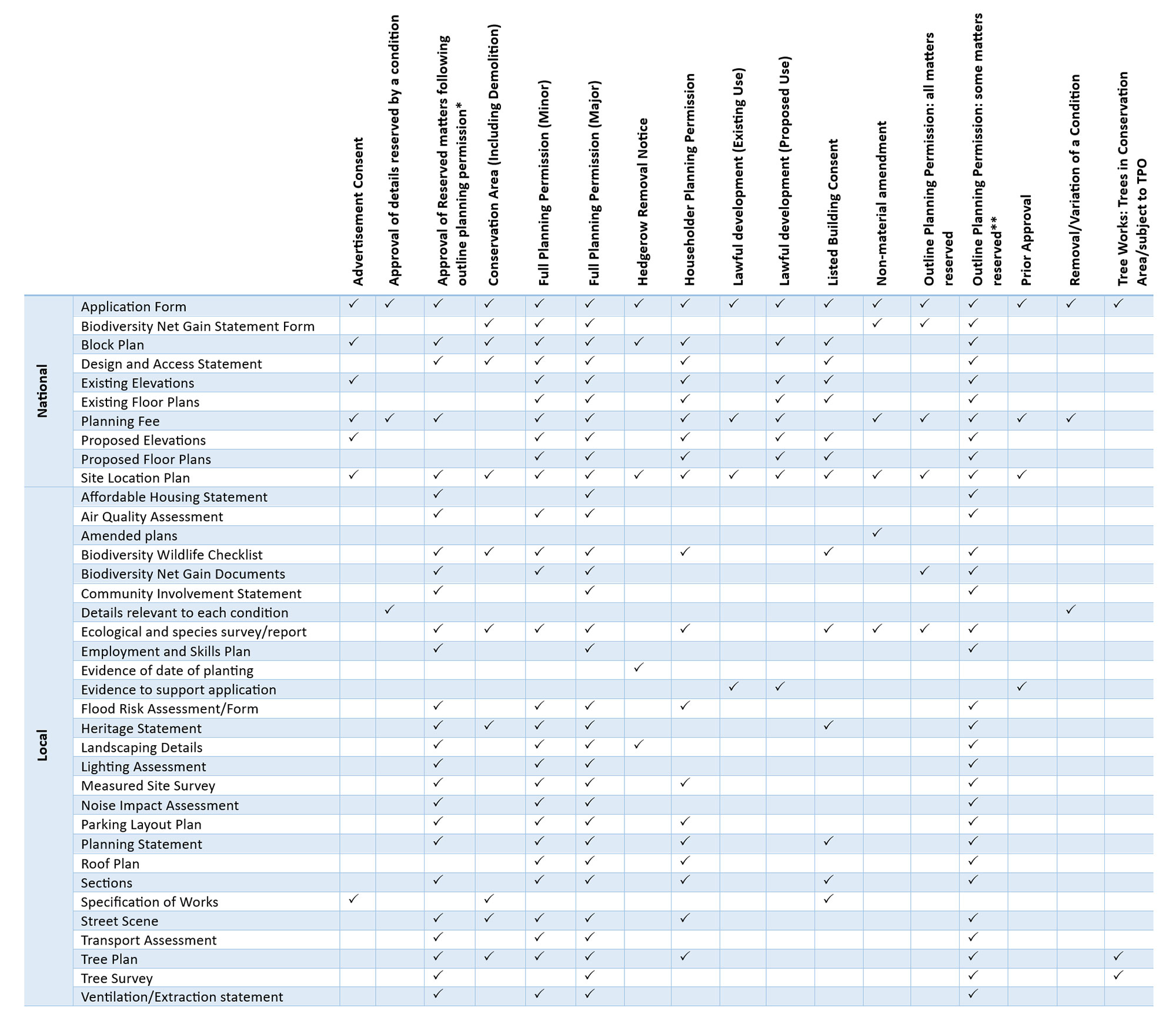
*You may need to provide additional plans and reports that are specific to the reserved matters of your application.
**You can get a custom list of requirements by submitting a pre-application.
Please use our alternative version of the local validation list if you are having trouble accessing the image.
If an item in this list is marked as required for your application, but you believe that in your application the item is not required, please include a statement about this with your application, justifying its exclusion.
Ordnance survey data
If you are submitting maps with Ordnance Survey data as part of your planning application, you must show the Ordnance Survey licence number on the plans.
Find out more about using Ordnance Survey maps for your application.
Further details about what is needed for each application
National requirements
There are several mandatory national requirements for planning applications by law, as set out in the Town and Country Planning (Development Management Procedure) (England) Order 2015.
These are needed by law to be submitted with your planning application. This means that it will be registered as valid by us, as the local planning authority.
-
- Must be completed in full
- The correct certificate has been completed:
- Certificate A – Sole Ownership and no agricultural tenants. If the applicant solely owns the land to which the application relates and there are no agricultural tenants
- Certificate B – Shared Ownership (All other owners/agricultural tenants known) If the applicant is not the sole owner and notice has been served on all other owners and/or agricultural tenants
- Certificate C – Shared Ownership (Some other owners/agricultural tenants known) If the applicant is aware of some other owners details and has taken all reasonable steps to find out the names and address of all the other owners but has been unable to do so
- Certificate D – Shared Ownership (None of the other owners/agricultural tenants known) If the applicant has taken all reasonable steps to find out the names and address of all the other owners but has been unable to do so
- The declaration has been signed
-
This document will demonstrate whether you want to claim exemption from statutory biodiversity net gain or how you have considered the mandatory biodiversity net gain requirement and have met validation requirements, as set out in our Biodiversity Supplementary Planning Document (SPD) April 2024.
The Biodiversity Net Gain Statement form must be submitted, along with any documentation identified through completion of the form, with your application.
-
A plan with a scale that should be 1:500 or 1:200 and show:
- The proposed footprint of the development and/or
- Where the advertisement will be situated and/or
- Hedgerow or tree(s) to be removed
-
A design and access statement is a report to be included with certain applications for planning permission and applications for listed building consent. They provide a framework for applicants to explain how the proposed development is a suitable response to the site and its setting. It is also used to demonstrate that it can be accessed by prospective users.
The level of detail in a design and access statement should be proportionate to the complexity of the application and tailored around this, but should not be long.
A design and access statement must:
(a) explain the design principles and concepts that have been applied to the proposed development; and
(b) demonstrate the steps taken to appraise the particular characteristics of the application site and its wider setting, and how the design of the development takes that context into account
Design and access statements can aid decision-making by help local planning authorities and third parties to better understand the analysis that has underpinned the design of a development proposal.
For minor development proposals that require both a Heritage Statement and a Design and Access Statement, a single comprehensive document that addresses both requirements can be submitted.
-
A plan with a scale that should be 1:50 or 1:100 and show clearly what is already there.
All external sides must be shown.
The plan must show the direction of north, include an individual reference, the version number and date of production.
-
A plan with a scale that should be 1:50 or 1:100 and show clearly what is already there.
All floors must be shown.
The plan must show the direction of north, include an individual reference, the version number and date of production.
-
You can find out the correct fee for your planning application by visiting the Planning Portal's guide to fees for planning applications in England.
If you are unsure of the fee applicable, please contact us using the details at the bottom of this page.
-
A plan with a scale that should be 1:50 or 1:100 and show clearly the proposed works in relation to what is already there. All external sides of the proposal must be shown.
Where a proposed elevation adjoins another building or is in close proximity, the drawing should clearly show the relationship between the buildings and detail the positions of the openings on each property.
The plan must show the direction of north, include an individual reference, the version number and date of production.
-
A plan with a scale that should be 1:50 or 1:100 and show clearly the proposed works in relation to what is already there.
Where existing walls or buildings are to be demolished, these should be clearly shown.
The plan must show the direction of north, include an individual reference, the version number and date of production.
-
A site location plan should:
- Be based on an up-to-date map
- The scale should be 1:1250 or 1:2500
- Wherever possible, the plan should be scaled to fit onto A4 or A3 size paper
- It should identify enough roads and/or buildings on land adjoining the application site to make sure that the exact location of the application site is clear
- Have the application site's edge clearly shown with a red line
- Include all land necessary to carry out the proposed development (for example, land required for access to the site from a public highway, visibility splays, landscaping, car parking and open areas around buildings)
- A blue line should be drawn around any other land owned by the applicant, close to or adjoining the application site
If you are submitting a plan with Ordnance Survey data as part of your application, you must show the Ordnance Survey licence number on the plan.
Local requirements
The National Planning Policy Framework (paragraph 44) says that we need to publish a list of our information requirements for applications for planning permission. These are the local requirements that we list below. These forms, plans and other information can be requested by us, as the local planning authority for planning applications in Rushmoor.
If an item in this list is marked as required for your application, but you believe that in your application the item is not required, please include a statement about this with your application, justifying its exclusion.
-
The statement should include:
- The total numbers of affordable housing
- The mix of affordable housing by house type
- The mix of affordable housing by tenure
- Plans showing the location of affordable housing with a schedule detailing the bedrooms, accessibility category (building regulation standard) and unit size of each property (GEA and GIA)
- Details of the basis of calculation of any service charges, ground rents or management fees to be applied to the affordable housing
- Summary of design and construction detail and equipping of the affordable housing, including curtilage design and access
- Phasing of the development, including the provision of affordable housing
- Information about how the affordable housing is to be transferred, managed, allocated and let to meet needs, and details of the registered provider where involved
- For outline applications, where it is not possible to specify the affordable housing provision in detail, a statement of intent should be submitted outlining how affordable housing is intended to be provided and whether the site will comply with the provisions set out in our Affordable Housing Supplementary Planning Document
- Provide any other details which you feel would be beneficial to support the provision of affordable housing. This may include rationale and evidence to support any off-site provision and viability evidence
-
Proposals for development that:
- Introduces sensitive development close to significant sources of pollutants
- Or for development likely to result in significantly increased local emissions
Will need to provide an air quality assessment, such as commercial kitchens, commercial development, industrial development and Farnborough Airport.
The assessment must be prepared by a suitably qualified person and consider the impacts of the proposal on the existing air quality environment and/or future occupants of the development. It also needs to demonstrate that all reasonable efforts are or will be employed to make sure that such odours will not impact on amenity or the quality of life of local communities.
Details of adequate mitigation will be required to demonstrate an acceptable development can be achieved and that emissions can be controlled or minimised.
Dust and emissions can often be a particular problem during the demolition and construction phases of any development. Adequate controls will need to be considered, and construction management plans, where deemed necessary, will be required to set out what measures will be employed to minimise emissions from any associated activities.
-
The proposed changes must be clearly shown on an updated proposed plan.
The plan must show the direction of north, include the individual reference, an updated version number and an updated date of production.
-
The biodiversity checklist helps you work out if your application may have an impact on the natural environment.
Where the checklist flags a potential impact to legally protected species, you are required to submit species specific ecological surveys to identify species presence or absence and to make sure your development will not adversely affect protected species.
Visit the Biodiversity checklist page on the Hampshire County Council website to download and complete the appropriate checklist for your development.
The checklist, and any protected species ecological surveys identified whilst completing the form, must be submitted with your application.
-
The Statutory Biodiversity Metric Calculation Tool (in Excel format, with no tabs deleted) must be completed as appropriate and submitted with the application. All relevant baseline tabs must be completed and relevant post development tabs completed, as far as possible, showing indicative plans.
Submission should have take into account to the Biodiversity Metric Principles included in Statutory biodiversity metric tools and guides - GOV.UK
If your project qualifies as a small development, you can choose to use the statutory biodiversity metric tool, or if you prefer, you can use the small sites metric if your development meets the criteria to do so.
-
A community involvement statement is required for all major applications involving:
- Residential schemes over 100 units
- Employment and warehouse/distribution schemes over 10,000 sq. m
- Retail schemes totalling over 5,000 sq. m
- Leisure schemes totalling over 2,000 sq. m
The statement should outline the techniques used to engage with stakeholders and the community, and demonstrate that the views of the local community have been considered.
Further information can be found in Section 7 of our Statement of Community Involvement (SCI).
-
Approval of details reserved by a condition
As described in the condition as set out on the decision notice, adequate detail must be submitted to enable the approval of the condition.
Where one application is used to submit details of more than one condition, adequate detail for each conditions relating to the application must be submitted.
Removal / variation of a condition
Plans/documents that set out the proposed change and address the resulting material changes.
-
Where an application has potential to adversely affect protected species or habitats, further ecological surveys are required to establish presence or likely absence of species and extent of impacts.
Reports should identify measures to avoid, reduce or mitigate for impacts and such measures should be taken account of within your application.
Surveys and reports should follow best practice and be prepared by a suitably qualified person.
-
A plan that makes a commitment to deliver employment and training, and social value opportunities through the construction phase of developments. Following the CITB benchmarks, this could include apprenticeships, work experience, curriculum support, and on-the-job training for local people.
For more information contact the Economy and Growth team using the details at the bottom of this page.
-
The Hedgerow Regulations 1997 are designed to give protection to important hedgerows in England and Wales.
The Regulations apply to any hedgerow which:
- Has existed for 30 years or more or
- Grows in, or adjacent to any common land, Local Nature Reserve, Site of Special Scientific Interest, or land used for agriculture, forestry or the breeding or keeping of horses, ponies or donkeys and
- Has a continuous length of at least 20 metres, or if less than 20 metres, meets another hedgerow at each end
The regulations do not apply to any hedgerow within the curtilage of or marking a boundary of the curtilage of a home.
If the hedge does not meet criteria b or c above and has not existed for 30 years or more, sufficient evidence of date of planting is required. This could be in the form of witness statements, or photographic evidence for example.
-
Lawful development certificate applications
Evidence that is relevant, detailed and provides sufficient information to demonstrate that the development is lawful.
Prior approval: larger home extension
A detailed block plan showing the footprint of the proposal.
All other prior approval applications
Where development is permitted by any Class in Schedule 2 of the General Permitted Development Order, which is expressed to be subject to prior approval, an application must be accompanied by a supporting statement to address the points raised in the relevant part of the legislation.
-
You can check the flood zones map on the GOV.UK website.
A flood risk form must be completed and submitted for all householders and other minor extensions in flood zones 2 and 3.
A flood risk assessment is required for:
- Minor development in flood zones 2 and 3
- Change of use in flood zones 2 and 3
- Development and change of use within Zone 1, with a site area of 1 hectare or more
-
Required for:
- Planning applications affecting a conservation area or its setting
- Planning applications affecting a listed building, its curtilage or setting
- Planning applications affecting a heritage asset, including its setting
- Applications for Listed Building Consent
The level of detail within the heritage statement should be proportionate to the asset's importance and the scope of the proposed works. Sufficient detail must be provided to demonstrate an understanding of the history, character, significance and setting of the heritage asset.
There are two types of heritage asset:
- Designated heritage asset: listed building, conservation area, scheduled monuments and registered parks and gardens.
- Non-designated heritage asset: buildings or structures of local importance included on a local list, areas of archaeological importance, unknown buildings of importance.
A heritage statement must include:
- A description of the heritage asset and its setting
- An assessment of the heritage assets significance (exterior and interior if relevant)
- A clear and full explanation of how the heritage asset and its setting informed the design proposals
- An assessment of the impact of the proposal
- A statement of justification for the works, together with any mitigation proposed
If applicable, you can search for archaeological information on Hampshire County Council's historic environmental records website.
Further information can be found for:
- Applications relating to a conservation area
- Applications relating to locally listed buildings
- Applications relating to nationally listed buildings
For minor development proposals that require both a heritage statement and a design and access statement, a single comprehensive document that addresses both requirements can be submitted.
-
The information provided should be appropriate to the scale and nature of the proposed development and indicate:
- The extent of existing and proposed planting areas and the type of planting within them
- Locations and types of new trees
- Areas and type of hard surfacing
- Location and nature of boundary treatments
- Earthworks / ground level changes
Planting plans should provide sufficient detail including: plant species, size, density, numbers, and for trees and some shrubs information relating to the root condition (such as pot, bare root, root balled, air pot, etc).
-
A lighting assessment should include:
- A description of the proposed hours of operation, light spillage, light levels and column heights
- A layout plan of the proposed development site showing beam orientation
- Details of the design and specification of the proposed equipment
- Details of the expected impact on neighbouring residential properties, roads, listed buildings, and conservation areas
- Impact on protected or priority species and proposed mitigation in order to maintain or enhance the biodiversity in the area
- A statement of any proposed measures to mitigate or compensate for the possible impacts of the proposed development
-
A measured site survey is required for:
- Sites of irregular or complex shape
- Infill developments
- Applications covering a large area
- Any development involving a substantial change in ground levels
The scale should be 1:200 or a topographical drawing showing key dimensions.
Plans must show the direction of north, include an individual reference, the version number and date of production.
-
Required for:
- Residential developments
- Medical developments, educational developments and day nurseries
- Drinking facilities, such as public houses and nightclubs
- Places of worship
- Indoor and outdoor sports facilities
- Industrial developments using noisy machinery
- Wind turbines
- Developments adjacent major sources of noise, such as roads, railways, industrial and commercial
- Any other use that will generate high levels of noise or vibration
This must be prepared by a suitably qualified acoustician and outline the potential sources of noise generation, how these may have a negative impact on local amenity and environmental receptors, and how this will be mitigated including details of sound insulation measures.
For developments likely to be affected by noise associated with the strategic road network, please contact Highways England for details of its noise assessment requirements.
-
Required if there is a loss of parking space(s) or an increase in bedrooms.
The scale should be 1:500 or 1:200 and show the existing and proposed parking having regard to the car parking standards as set out in the Car and Cycle Parking SPD.
The plan must show the direction of north, include an individual reference, the version number and date of production.
-
A planning statement should:
- Identify the context and need for a proposed development
- Include an assessment of how the proposed development accords with relevant national and local planning policies
- It may also include details of consultations with the local planning authority
-
Required for:
- New properties and/or where there is complex integration of roof forms or dormer windows - the scale should be 1:50 or 1:100 and include details such as materials, vents, roof lights or lanterns
- Lawful development certificate for a roof extension - at least one of the plans submitted must include calculations to show the proposed increase in cubic meters
All plans must show the direction of north, include an individual reference, the version number and date of production.
-
The scale should be 1:50 or 1:100 and show:
- A cross section(s) through the proposed building(s)
- Where a proposal involves a change in ground levels, illustrative drawings should be submitted to show both the existing and finished levels to include details of foundations and eaves
- Plan(s) to demonstrate how proposed buildings relate to existing site levels and neighbouring development, which could show existing site levels and finished floor levels (with levels related to a fixed reference point off-site)
- Details of the design and location of any retaining walls
- Where no changes to levels are proposed, the submitted plans should clearly state that this is the case
The plan must show the direction of north, include an individual reference, the version number and date of production.
-
A specification of works set out, in detail, showing/describing exactly how the works will be undertaken.
This includes details of removal, fixing, proposed materials and so on, as appropriate to the application.
-
This could be an artist's impression, or a plan at a scale of 1:100 or 1:200, to show the proposal in context with the immediately neighbouring buildings.
Required for infill properties, including replacement properties, or extensions that increases the height of the ridgeline where there are immediately adjacent neighbours.
-
The detail contained within the transport assessment should reflect the scale of the development and the extent of the transport implications of the proposal.
The assessment should quantify the travel characteristics of the development by all modes of travel, identify the impacts on the existing transport infrastructure and clearly outline proposed transport infrastructure.
-
- The scale should be 1:200 or 1:500
- Show clearly the location of tree(s) and their spread in relation to what is already there. This includes within the site area and adjoining properties
- Must include trees that are subject to a Tree Preservation Order (TPO) are within a Conservation Area or within falling distance of the site area
- The tree(s) should be clearly labelled (for example, T1, T2 and so on)
The plan must show the direction of north, include an individual reference, the version number and date of production.
-
To accompany a planning application
Where there are tree(s) within the application site, or on land adjacent to the application site that could influence or be affected by the development (including street trees), especially where the tree(s) are subject to a Tree Preservation Orders (TPO) and/or in a Conservation Area, the survey must include information on which trees are to be retained and the means of protecting these trees during construction works.
The survey must be prepared by a suitably qualified person.
Application for tree works
Where the tree(s) are covered by a Tree Preservation Order (TPO) and the application has been submitted due to disease, fears it may break or fall, subsidence or other structural damage, the survey must be written by an appropriate expert and include diagnostic information/technical evidence.
-
Required for:
- Proposal for new restaurants and cafes
- Proposal for new public houses or other drinking establishments
- Proposal for new hot food takeaways
- Proposal for new laundrettes
- Applications for mixed use food and drink
- Major retail business, industrial, leisure or similar development where substantial ventilation or extraction equipment is proposed
The ventilation/extraction statement must include the details (elevational drawings showing size, location, and external appearance), position and design of the equipment, include an acoustic assessment and noise mitigation measures.
Or, a statement that no ventilation or extraction equipment is proposed.
Contact us